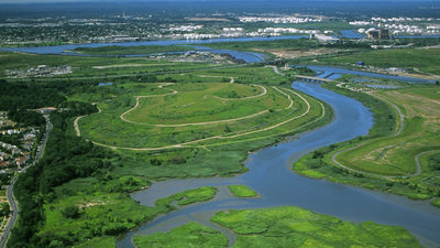
In the 1990s, New York chose wetlands over conventional storm sewers on Staten Island; the Bluebelt strategy saved taxpayers $80 million in infrastructure costs. Instead of laying miles of underground concrete pipes, the city preserved and restored natural streams, ponds, and freshwater marshes to direct rainwater safely into surrounding bays.The financial and environmental success of the Staten Island Bluebelt model provided the blueprint for water management across New York City. The city’s overarching framework, outlined in the New York City Wetlands Strategy and the PlaNYC 2011 Waterways plan, officially incorporated natural habitats into the municipal infrastructure toolkit alongside conventional treatment facilities.According to figures published in the New York City Wetlands Strategy, urban expansion over the past century wiped out more than 90 per cent of New York City’s freshwater wetlands and roughly 85 per cent of coastal wetlands across the New York-New Jersey Harbor Estuary. Hundreds of miles of natural stream corridors were paved over, buried in underground pipes, or cut off from their natural floodplains.Despite these losses, important ecosystems survived, particularly in Staten Island, the Upper East River, Western Long Island Sound, and Jamaica Bay. Jamaica Bay remains one of the largest tidal wetland systems in the region, serving as a vital stopover on the Atlantic Flyway for over 325 bird species and supporting more than 100 fish species.
Combining green and grey city infrastructure
The municipal planning framework detailed in the PlaNYC 2011 Waterways document established a dual approach to managing runoff, combining grey engineering with green infrastructure.Grey infrastructure relies on concrete storage tanks, pumping stations, sewer mains, and centralized treatment plants. By 2011, New York City operated 14 wastewater treatment facilities handling 1.1 billion gallons of sewage every day during dry weather, following more than $6 billion in municipal harbor water-quality investments since 2002.However, dry-weather capacity did not solve combined sewer overflows (CSOs). In older municipal networks where rainwater and sewage share the same pipes, heavy downpours overwhelm treatment plants, causing direct discharges of untreated wastewater into local waterways. Although the city raised its CSO capture rate from 30 per cent in 1980 to more than 72 per cent by 2010, an estimated 30 billion gallons of CSOs still entered harbor waters annually.To address this volume, the city launched its Green Infrastructure Plan in 2010, committing $1.5 billion over 20 years to capture stormwater at ground level before it enters the sewer system. Municipal evaluations projected that pairing green absorption areas with targeted grey construction would cut CSO volumes by 40 per cent while saving ratepayers over $2 billion compared to building grey infrastructure alone.Major grey engineering investments remained central to the strategy, including large CSO detention facilities at Spring Creek, Paerdegat Basin, and Flushing Bay to store excess rainwater during peak storm events.
Legislative mandates and site restoration targets
Local Law 31 of 2009 legally obligated the city to formulate a comprehensive strategy to conserve, protect, restore, and expand wetlands and adjacent buffer zones, setting a goal of no net loss of wetland area.While federal and state legislation protected large tidal wetlands and freshwater areas larger than 12.4 acres, smaller freshwater marshes remained vulnerable to private construction projects. The strategy established stronger local zoning rules, improved mapping, active land acquisition, and revised mitigation policies to protect small-scale urban wetlands.Specific restoration sites targeted in the municipal plan included Pugsley Creek, Soundview Park, Randall’s Island, Calvert Vaux Park, Meadow Lake, Freshkills North Park, and Paerdegat Basin, alongside ongoing ecological stabilization efforts in Jamaica Bay.The framework also encouraged the creation of a natural areas conservancy to coordinate public and private funding for long-term ecological care across the five boroughs.
Tackling nitrogen runoff and climate surges
Urban waterways face ongoing ecological pressures from nutrient pollution, particularly high nitrogen levels in treated wastewater discharge. Excessive nitrogen triggers large algal blooms, which deplete dissolved oxygen levels and create dead zones that threaten marine life.At the same time, rising sea levels and intense coastal storms require natural buffer zones to break wave energy and absorb storm surges. Reconstructed tidal marshes, biofiltration swales, and natural stream corridors serve a double purpose by filtering heavy metals and trapping sediment while providing physical flood protection for nearby neighborhoods.By combining Staten Island’s natural drainage principles with targeted facility upgrades, local legislation, and biological restoration, the city established a multi-layered urban resilience strategy built to handle changing weather patterns.