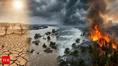
A vast pool of abnormally warm water is gathering strength across the tropical Pacific, and the world’s best climate models now agree: El Nino is not only back, it is turbocharged.This event is forecast to reach “very strong” or even “super” status by late 2026, with sea surface temperatures in key Pacific zones more than 2°C above normal and some runs pushing toward 3–4°C — levels competitive with the strongest El Ninos in recorded history.As temperatures rise, the odds of extreme weather, food price shocks and public health crises climb alongside them.Scientists are not just tracking this monster; some are beginning to ask a provocative question: could humanity partially “switch off” or soften a super El Nino by deliberately tinkering with clouds over the Pacific — effectively dimming the sun over the engine room of the global climate?Before getting to those geoengineering ideas, it helps to understand what El Nino is, why this one is so worrying, and how its heat ripples through every continent.
What is El Nino?
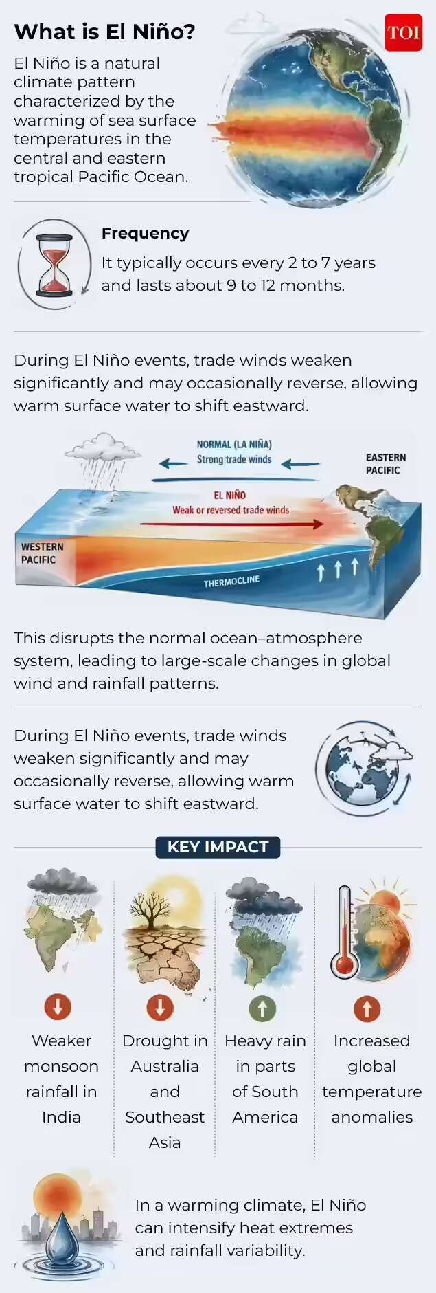
El Nino is part of a larger oscillation in the tropical Pacific known as ENSO — the El Nino–Southern Oscillation — a swing between warm (El Nino), cool (La Nina) and neutral phases.
What is El Nino
In a “normal” year, trade winds blow steadily from east to west, piling warm surface water up near Indonesia and Australia, while cooler water wells up near South America.During El Nino, those trade winds weaken or even reverse, and the whole system rearranges itself:
- Warm water sloshes eastward, spreading across the central and eastern equatorial Pacific.
- Sea surface temperatures in equatorial Pacific rise at least 0.5°C above average for several months; in strong events, anomalies exceed 2°C.
- As the ocean warms, convection shifts eastward, changing where thunderstorms form and how the jet streams are steered.
That rearrangement doesn’t stay local.Because the tropical Pacific is the heart of the global circulation, a strong El Nino sets off a chain of “teleconnections” — long-distance links that reshape rainfall, temperature and storm tracks from North America and Latin America to Africa and Asia.In short: El Nino is not just “hot water in the Pacific”. It is a planetary-scale reconfiguration of heat and wind.
Why this one may be ‘super’
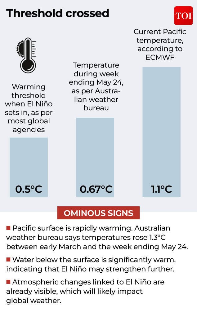
Forecast centers on both sides of the Atlantic are unusually aligned and unusually alarmed.NOAA’s Climate Prediction Center reports El Nino conditions already present, with temperatures in equatorial Pacific around 0.7°C above average and subsurface heat strongly positive — a telltale sign that more warmth is waiting to surface.
Forecast centers on both sides of the Atlantic are unusually aligned and unusually alarmed.
Multi-model ensembles now give roughly a two‑thirds probability that sea surface temperature anomalies will exceed 2°C by Northern Hemisphere winter, qualifying as a “very strong” El Nino and potentially reaching the “super” range.Several features make the brewing 2026–27 event stand out:
- Model consensus and intensity: NOAA’s Geophysical Fluid Dynamics Laboratory ran its model dozens of times; every run produced an El Nino competitive with the strongest events since 1950. Some projections are “close to unprecedented”, in the words of Columbia University scientist Michael Tippett.
- Rapid strengthening window: The WMO warns that the most rapid intensification is likely between July and September, with impacts expanding through autumn and peaking in winter.
- Hot background climate: Global sea surface temperatures and air temperatures are already near record highs, so this El Nino is layering an extreme event on top of an unusually warm planet.
That last point is critical.Strong El Ninos in the past — notably 1997–98 and 2015–16 — set global temperature records and triggered multi‑billion‑dollar damage through floods, droughts and crop failures.The current event is developing in a climate that has warmed further, which increases the risk that familiar impacts will be pushed into more dangerous territory.
How a Super El Nino warps global weather
Once a super El Nino matures, it acts like a giant thermal engine, pumping heat and moisture into the atmosphere and pulling weather systems into new patterns.The details differ by region, but some broad tendencies are well established from past strong events and current forecasts.
North America: Storms in the south, stress in the north
Across the United States and southern Canada, forecasters expect:
- Wetter, stormier southern tier: The subtropical jet stream typically shifts so that more storms barrel across the southern US, bringing heavy rainfall to parts of California, the Southwest and the Southeast. This can relieve drought but also raises flood risk, especially when “atmospheric rivers” — long plumes of concentrated moisture — make landfall more often along the West Coast.
- Hotter, drier north and Pacific Northwest: The Pacific jet tends to move south, leaving states in the northern US and Pacific Northwest warmer and drier, with reduced snowfall in the northern Rockies. That combination sets up drier soils, early snowmelt and higher wildfire risk into the following summer.
The 2015–16 super El Nino was associated with spikes in mosquito‑ and rodent‑borne diseases in parts of the US, highlighting how altered rainfall and temperature can change the geography of infection risk. Public health agencies are watching similar signals now.Atlantic hurricane activity, meanwhile, is likely to be suppressed.
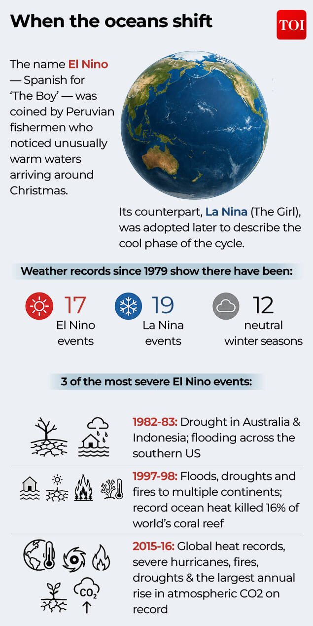
There have been 17 El Nino events since records for the weather pattern started being kept in 1979.
Strong El Nino events increase vertical wind shear over the tropical Atlantic, making it harder for tropical storms to organise into hurricanes.NOAA expects a quieter‑than‑normal Atlantic hurricane season, with fewer storms than the long‑term average.In contrast, the eastern Pacific tends to see more hurricane activity, especially affecting western Mexico and occasionally threatening Hawaii.
Canada and the Arctic: Mild winters, fire risk
In Canada, El Nino’s fingerprint usually shows up as:
- Milder, less snowy winters, especially in western provinces, extending into spring.
- Earlier snowmelt and drier soils, which, combined with below‑average rainfall, set the stage for more severe wildfires in the subsequent summer.
Given the recent history of record‑breaking Canadian fire seasons, an overlay of super El Nino warmth is a major concern for fire managers and communities downwind across North America.
Latin America and the Caribbean: Droughts, deluges and heat
In Latin America, the pattern flips north to south:
- Central America and northern South America (Colombia, Venezuela, northern Brazil) tend to face drier conditions and elevated wildfire risk.
- Southern Brazil, Uruguay, northern Argentina and central Chile are more likely to see above‑average rainfall and flooding.
The Caribbean has previously experienced once‑in‑centuries drought during strong El Nino events, such as the severe multi‑year dry spell linked to the 2015–16 event.Current regional assessments warn that a super El Nino could again stress water supplies and agriculture from Central America to the Caribbean basin.
Asia and Africa: Food security on the line
El Nino’s influence reaches deep into the monsoon belts and staple crop regions:
- In South and Southeast Asia, El Nino is often associated with weaker monsoons and reduced rainfall, which can depress yields of rice and other staples, as seen in previous events affecting India and neighboring countries.
- Parts of East and Southern Africa can swing between drought and flood depending on the season and local teleconnections, but strong El Nino events have been linked to major agricultural disruptions and heightened food insecurity.
Because this event is developing on top of already elevated global temperatures and marine heatwaves, experts warn that crop stress, heat waves and water scarcity could hit multiple breadbasket regions simultaneously — raising the risk of food price spikes and knock‑on effects on health and political stability.
The global economy and health
El Nino doesn’t just shift weather; it moves money and mortality:
- One recent analysis estimated that El Nino‑related disruptions have caused trillions of dollars in global economic losses when accumulated over decades.
- Food production shocks can push millions into hunger and malnutrition, particularly in countries without strong safety nets.
- Heat waves, flooding and disease outbreaks add to health burdens and strain hospitals and emergency services.
That is why the World Meteorological Organization is urging governments and UN agencies to treat this brewing super El Nino as a global risk multiplier, and to step up early warning systems, disaster preparedness and support for vulnerable communities.
Can we ‘squish’ a super El Nino?
Against this backdrop, a group of researchers has floated a radical idea: use solar geoengineering, specifically “marine cloud brightening”, to blunt the worst impacts of a super El Nino.
Dimming the Pacific
Marine cloud brightening involves spraying tiny particles into low‑lying marine clouds to make them whiter and more reflective, so they bounce more sunlight back to space and cool the ocean surface below.The new study led by scientists at Scripps Institution of Oceanography and collaborators treats this as a finely targeted intervention: not a global programme, but a tactical attempt to cool part of the southeast Pacific in order to change El Nino’s trajectory.
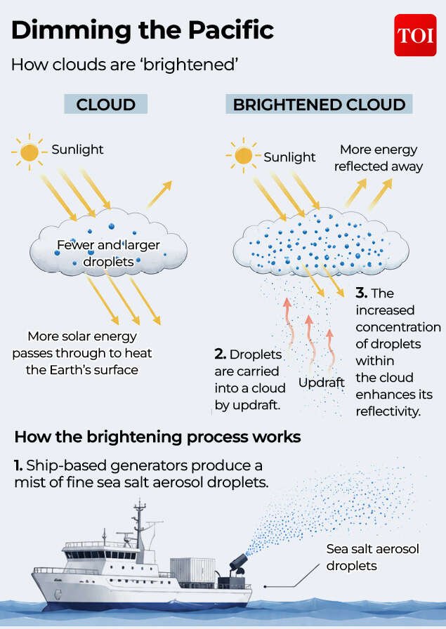
Marine cloud brightening involves spraying tiny particles into low‑lying marine clouds.
Because no one is willing to run large‑scale experiments with deliberate spraying over the Pacific yet, the team turned to a “natural experiment”:
- During Australia’s Black Summer bushfires of 2019–20, smoke plumes injected reflective particles into clouds over the Pacific.
- Previous work found those smoke‑modified clouds reflected more sunlight and helped cool parts of the ocean, contributing to a subsequent La Nina event.
Using climate models, the researchers isolated the cloud‑brightening‑like effect of these fires and then asked: what if we applied a similar pattern of reflective clouds before two historic strong El Ninos — 1997–98 and 2015–16?The simulations showed that an early, sustained brightening of targeted clouds could:
- Weaken El Nino‑like warming and shift the system toward neutral or La Nina‑like conditions, dampening the extreme rainfall and heat associated with the warm phase.
- Increase La Nina’s cooling and drying influence by around 40% in some scenarios, depending on timing and duration.
In crude terms, the models suggest that carefully timed marine cloud brightening might partially “kill” — or at least seriously weaken — a developing super El Nino.
Why scientists are cautious
Despite the headline‑grabbing potential, the scientists behind the work emphasise this is proof of concept, not a policy prescription.Several major caveats loom:
- Technical feasibility: Engineering the right spray devices is nowhere near solved. Independent experts note that existing prototypes have spray rates about two orders of magnitude too small for real‑world deployment at the necessary scale.
- Risk of overcorrection: If brightening works too well, it could trigger an unusually strong La Nina, with its own pattern of destructive floods and droughts — potentially a “mega La Nina” beyond observed experience.
- Uneven regional impacts: El Nino creates losers and winners. For example, California relies on El Nino‑driven rainfall to refill reservoirs, even though those storms can be dangerous. Blunting El Nino might reduce damage in some places while harming water security in others.
- Governance and ethics: Who decides to pull the trigger on a transboundary intervention that redistributes climate risks across continents? And does the availability of such “quick fixes” distract from cutting greenhouse gas emissions?
Some skeptics argue that the complexity of the climate system, combined with the risk of unintended consequences and the need for potentially repeated interventions, make targeted geoengineering a perilous path.Others counter that for rare, highly destructive events like super El Ninos, it is at least worth exploring whether temporary, limited interventions could lower the biggest peaks of risk — especially for vulnerable communities who suffer most from climate extremes.What is clear is that we are “a long way away” from practical deployment. Both technical and political questions remain wide open, and the researchers themselves stress that their work is meant to open a conversation, not close it.
The near-term reality
For now, the tools available to “squish” a super El Nino are conventional rather than a sci‑fi ‘kill-switch’:
- Better forecasting and early warning to give farmers, cities and health systems months of lead time to adjust planting schedules, manage reservoirs and prepare for floods or heat waves.
- Resilient agriculture, from drought‑tolerant crop varieties to improved irrigation and soil management, to reduce yield shocks when monsoons falter or rainfall patterns shift.
- Stronger infrastructure and emergency planning, including flood defenses, wildfire management and heat‑health action plans.
- Emissions cuts and long‑term climate mitigation, which won’t stop this El Nino but will reduce the risk that future events play out on an even hotter, more volatile baseline.
In other words, the immediate fight against this particular monster is about preparation, not planetary surgery.Geoengineering ideas sit in the background as a controversial, long‑term research topic, while the pressing task for governments and societies is to use existing tools to blunt the impacts they already know are coming.