The emergence of a fresh alert on the climate front continues to make rounds in meteorological circles across the globe. Preliminary reports indicate that the currently forming El Niño in the tropical Pacific Ocean will grow to become extremely strong within the next few months. There is a possibility that it will be the strongest ever recorded. Such a development raises fears of unprecedented global heatwaves and climatic disturbances. Observations on the ocean surface are intensifying amid signs of warming much sooner and more rapidly than anticipated.The forecast centres such as NOAA and the Australian Bureau of Meteorology continue to monitor the situation closely. There is growing evidence that El Niño conditions may emerge soon, with a chance of strengthening further into late 2026, as reported by the BBC. For now, the situation remains uncertain but closely watched.
El Niño 2026: Early signs of Pacific Ocean warming appear
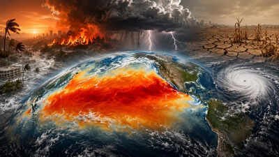
The tropical Pacific has started to show clear signs of warming. Current data suggests sea surface temperatures are around 0.5°C above the long-term average in key monitoring regions. This level is often seen as an early indicator of El Niño conditions beginning to form.Meteorologists reportedly say the transition is happening faster than usual. The Pacific has shifted from cooler La Niña conditions in the previous cycle, and is now warming again within a relatively short time frame. This kind of quick swing does not happen every year. Experts suggest this early warming could be the first stage of a stronger El Niño pattern. However, they also caution that seasonal forecasts can change quickly, especially during spring and early summer when atmospheric patterns are unstable.
What defines a strong El Niño event
A strong El Niño is typically quantified by the Niño3.4 index of the Pacific Ocean. The Niño3.4 index is an important region used by scientists for monitoring changes in sea surface temperatures relative to their historical averages. An El Niño event with sea surface temperatures exceeding 1.5°C is categorised as a strong or even a “super El Niño.”Some current forecasts predict a scenario in which temperatures could rise beyond 2°C during the remainder of the year. There are even some forecasts showing very strong predictions of more than 2.5°C, thereby placing it among the most powerful events on record. According to scientists, the forecasts cannot be considered definite, but the trend among the models pointing towards a more powerful phase is interesting.
How a strong El Niño can change global weather
A strong El Niño does not stay limited to the Pacific Ocean. It typically influences weather patterns across the entire globe. The most common effects are a rise in the global average temperature. Reportedly, El Niño can also bring heavy rainfall and flooding to parts of South America. The agricultural sector is the most affected. Crop yields can fall in drought-hit areas, while flooding can damage farmland elsewhere. Experts in climate change and scientists have predicted that there could be serious humanitarian problems brought about by El Niño. El Niño consequences are beyond the weather itself, other issues include food prices, transportation, and water availability. Reportedly, there are also issues concerning food safety because several regions could experience low crop yield during El Niño years, which might impact global markets. Prices could also increase, affecting poor countries more than others.